Red Pine Pathway
Buy the $.99 downloadable map!
(This map is not geo-referenced)Trail Details


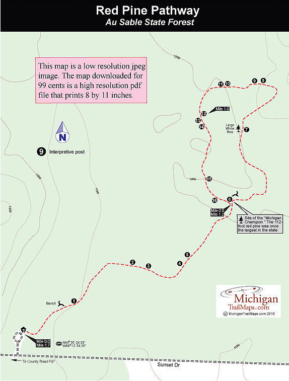
The Red Pine Natural Area covers 164 acres, but it is the 34-acre grove of virgin pines in the middle, most of them red pine, that makes the preserve so unusual. The stand of old-growth pine is composed of huge 200-year-old trees with some of the white pine rivaling the trophies at Hartwick Pines State Park. But while Hartwick Pines attract thousands of visitors every year, at Red Pine Naturalk Area you're often be the only one on the trail.
Winding through the stand of ancient trees is the Red Pine Pathway, an interpretive trail with 16 stops corresponding to a brochure that can be downloaded from this site. The loop path is often referred to as a 1.3-mile or 1.5-mile hike but we found it to be a bit longer at 1.7 miles. No matter the distance, the trail is an easy hike through a grove of impressive trees.
| Difficulty - Easy |
| Dog Friendly |
| Foot Path |
From the parking area the trail leads east into the woods and quickly arrives at a bench and then the first of the numbered posts and a giant red pine. This stand of virgin red pine is typical of the forests that once covered the heart of Michigan’s Lower Peninsula. The notion that this old-growth pine may have preceded the founding of our country is mind-boggling. Even children have a reverence for such large specimens. These are trees you don’t see in your backyard.
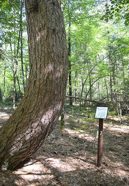
At Mile 0.5 the trail forks at a junction with a bench and post No. 6, which marks site of the “Champion of Michigan.” Once the largest red pine in the state, the tree measured more than 15 feet is diameter and stood 112 feet high before it died of old age. Post No. 7 marks a crooked red pine while opposite of the tree is one of the largest white pines along the trail.
After post No. 8, reached near Mile 1, the trail begins to loop back, and at post number 10 there will be towering pines all around you. Stand for a moment and absorb this setting. This is what Michigan looked like back in the early 1800s when such forests covered the northern half of the state. By 1930, however, 92 percent of Michigan’s old-growth forest had been cut, burned, or cleared for commercial, agricultural, or urban development.
Post number 16 points out a massive oak and scars on the base of pines that date back to forest fires in 1718, 1888, and 1928. At this point the trail returns to the intersection, where you bear right to return to the parking lot.
There are no facilities at the trailhead other than parking and an information board.
The trail is open year-round but the trailhead is difficult to reach during winters of heavy snow. A state park Recreation Passport is required to park at the trailhead.
To reach Red Pine Natural Area from I-75, take exit 222 and head north on County Road F-97 for 11 miles. Turn east (right) on Sunset Drive. The natural area is posted on Sunset Drive across from Kirtland Community College. At the natural area sign continue east on a dirt road, and within 0.5 mile you will arrive at the parking lot and trailhead for Red Pine Pathway.
Geo-referenced maps from MichiganTrailMaps.com range from $1.99 to $2.99 each.
Download the Avenza app from the App Store or Google Play


