Seven Lakes State Park: Green Trail Loop

Buy the $.99 downloadable map!
(This map is not geo-referenced)Trail Details


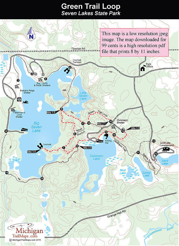
The Green Trail Loop is the most interesting route at Seven Lakes State Park as it winds through mature hardwoods forest, skirts the largest lakes in the park and has enough rolling terrain to keep you on your toes, whether you’re hiking or biking.
The park lists it as 2.1 miles in length but we included the Overlook spur, a walk of 2.25 miles. Either way if that’s too short, you can easily combine it with the Dickinson/Nature Trail Loop that would make for a 3.3-mile outing that passes five of the park’s seven lakes. The Yellow Shortcut will shorten the trail to 1.75 miles including the Overlook.
You can pick up the Green Trail Loop at either the Dickinson Shelter and picnic area or the boat launch on Dickinson Lake. Both have parking but neither has a source of drinking water.
| Camping |
| Difficulty - Easy |
| Dog Friendly |
| Multi-use Trail |
At the east end of the Dickinson shelter parking lot is post No. 14, marking where the path re-enters the woods. Pick up the trail here and within a 100 yards you’ll descend to post No. 10 for your first view of Dickinson Lake. The post marks the junction with the Dickinson Trail that heads south, reaching Spring Lake in less than a quarter mile and the campground in a half mile. To north is a set of log steps that lead back to the picnic area.
Two trails depart to the west and both end up at the handicapped-accessible fishing pier where often on summer weekends there are children trying to entice small panfish with worms and crickets. A paved path departs from the fishing pier and in a quarter mile from the start you cross the Dickinson Lake boat launch picking up the trail on its west side where it appears as a mowed lane.
You skirt the north end of the lake and quickly move into the cool shade of the hardwood forest. Within a quarter mile of the boat launch you arrive at post No. 8, marking the junction with the Red Trail Loop from the Big Seven Lake Picnic Area. Head west (right) and you’ll skirt a gurgling stream in a small ravine for a short but scenic stretch that ends at post No. 7, marking the spur to the Overlook. The spur is short and ends on the shoreline of Big Seven Lake, near a small island. You’ve hiked less than a mile at this point yet have gone from lake-to-lake with a scenic stream in between.
Returning to post No. 7, you head northeast (left) swing away from views of Big Seven Lake and arrive at post No. 6, marking the junction of the Yellow Shortcut, at Mile 1.27 and at post No. 5, marking a junction with the Red Trail Loop, at Mile 1.5. There is a bench here and in the fall you can sit and gaze at the marshy lower end of Little Seven Lake and the autumn colors that surround you. The trail remains above Little Seven Lake for a spell and then at Mile 1.75 arrives at post No. 17 marking the other end of the Yellow Shortcut.
The final leg of the Green Trail Loop includes hiking past a pair of green-carpeted ponds near post No. 16, more rolling terrain and then popping out at post No. 15 along the park road at Mile 2.12. On the other side of the road is the Dickinson Shelter and picnic area just a short walk away.
Seven Lakes features a 70-site, modern campground that overlooks Sand Lake in the southeast corner of the park. Sand Lake used to be a gravel pit at one time so the campground is an open grassy area in a partially wooded bowl. There's a swimming area on the lake and a trail that connects the campground to Spring Lake, a walk-in lake that can be fished for bluegills and bass.
On the west side of Big Seven Lake, the park maintains a beach and picnic area, which includes a bathhouse, designated swimming area, tables and grills. There is also a boat rental concession open daily during the summer. Boats for rent include canoes, rowboats and paddleboats. On the north end there is a picnic area with tables, grills and two shelters on a hill with a view of most of the lake. There is also a picnic area off the road to Dickinson Road with a shelter that the Green Trail passes through.
The park is open year round and a vehicle permit or annual state park pass is required to enter.
The park is a mile west of Holly with an entrance off Fish Lake Road, just north of Grange Hall Road. From 1-75, depart at exit 101 and head west on Grange Hall Road. Within four miles turn north on Fish Lake Road to reach the park entrance in a mile.
Call the park at (248) 634-7271. For a campsite contact Michigan State Park Central Reservations(800-447-2757; www.midnrreservations.com).


